
Methane, Roy Blunt Reservoir, Reservoirs vs Lakes
Methane From Lakes
In discussions of climate change, carbon dioxide from burning fossil fuels is usually at the top of the list of culprits. However, carbon dioxide isn’t the only greenhouse gas of concern.
Pound for pound, methane is vastly more potent as a greenhouse gas than carbon dioxide. Fortunately for us, much less methane than carbon dioxide is released to the atmosphere each year. When corrected for “global warming potential”, carbon dioxide accounted for 78.8% of U.S. greenhouse gas emissions in 2020 while methane accounted for 10.9% (source: EPA).
One study estimates that half of global methane emissions come from aquatic ecosystems, with the bulk of that (97%) coming from inland waters (lakes, rivers, wetlands, etc.). In lakes and ponds, methane is produced as organic matter is decomposed. This typically occurs in the sediment at the bottom of the lake, in the absence of oxygen. As methane builds up, it will enter the atmosphere by bubbling to the surface, simply diffusing out of the lake, or via the reservoir outflow (see image below).

Pathways of methane release from reservoirs
The diagram above shows how methane can exit a reservoir. 1) Diffusive emission occurs when the water is saturated with methane. 2) Ebullition occurs when methane bubbles are released from the sediment and move directly to the atmosphere. 3) Degassing and downstream emissions occur when methane leaves the reservoir via the spillway or through the dam. Source: EPA
Studies correlate primary production (a measure of the abundance of algae and cyanobacteria) with the quantity of methane produced in lakes and ponds. In general, the more productive a lake is, more organic matter (dead algae and other organisms) is available for decomposition. Primary production is driven by nutrient availability, so it is not surprising that methane production in aquatic systems also correlates with nutrients. The phenomenon of increasing primary production through excessive nutrient input is called eutrophication.
According to John Downing, director of Minnesota Sea Grant, “People do four important things that affect eutrophication: they eat, they excrete, they make more people who eat and excrete, and they alter landscapes and climate” (source).
Methane emissions from lakes is expected to increase by 30-90% in the next century due to human population increases and weather/climate changes (source). This increase equates to 18-33% of annual CO2 emissions from burning fossil fuels. In essence, with more people on the planet there will be more nutrient-rich sewage to manage and a need to increase agricultural intensity. It will be hard on our lakes.
On a positive note, if we do a good job of managing nutrients in our lakes, we can likely decrease methane production and reduce our lakes’ impact on climate change. As a bonus, our lakes will also be clearer and healthier.

Witnessing Methane Firsthand
As a graduate student, I was a teaching assistant for a science class for non-science majors. One evening we took a field trip to witness methane emissions at a local pond.
Getting pond sediment to release methane was simple; we just poked the mucky bottom with a stick. The bubbles that rose to the surface were methane. To “see” the gas we held lit candles over the water surface with garden rakes. Once ignited, methane’s distinctive blue flame briefly danced on the pond’s surface around the candle. If you try this yourself, be careful!
Roy Blunt Reservoir
With the final funding secured, the reservoir formerly known as “East Locust Creek Reservoir” is progressing toward completion. The waterbody will now be called Roy Blunt Reservoir. Designed to address the water needs of North Central Missouri, this Sullivan County reservoir will have a surface area of 2,300 acres (about the same size as Long Branch) and be located between Milan and Unionville, east of Highway 5. The reservoir has a projected cost of $225 million and will provide water to 10 counties. In addition to drinking water, the new reservoir will provide flood control and recreational services. The reservoir is expected to be completed in 2027 or 2028.
The Missouri Department of Transportation plans to reconfigure several roads and build four bridges. You can see a map of proposed the roadwork here.

Proposed location of Roy Blunt Reservoir and its watershed.
The Dam Truth About Reservoirs
Our program is called the Lakes of Missouri Volunteer Program, though it would probably be more aptly titled “The Reservoirs of Missouri Volunteer Program”. Except for a single oxbow lake, Creve Coeur in St. Louis, all of the water bodies ever sampled for the LMVP have been man-made reservoirs. For this reason, it seems appropriate that we discuss what it means to be a reservoir.
Reservoirs are constructed to address one or more needs such as drinking water supply, irrigation, recreation, flood control, power generation, or navigation. There are 2 broad categories of reservoirs, the valley reservoir and the off-river storage reservoir. The valley reservoir is most common in Missouri. To create a valley reservoir, a dam is constructed perpendicular to a river and the river subsequently pools up behind the dam. The off-river storage reservoir is created near a river and water is diverted to it via gravity or by pumping. Delaney Lake in Mississippi County is an example.
In reservoir construction there are 4 basic dam types: Arch dams are made out of concrete in an arch shape, with the convex side facing upstream. Arch dams can be much thinner than other types of dams, because they incorporate the inherent strength of the arch shape in their design. This type of dam requires very solid rock and for that reason is reserved for narrow, steep sided valleys. An example is the Hoover Dam on the Colorado River.
Buttress dams are made out of concrete (or masonry) and are triangular in cross section. This type of dam is strengthened by regularly spaced supports, or buttresses, along the downstream side of the dam. The supports help to counter the pressure of the water against the dam wall. An example is Powersite Dam at Lake Taneycomo.
Gravity dams are also made of concrete (or masonry). They are essentially giant blocks that use their weight to hold back the water. Gravity dams need to be built on a solid foundation of rock. An example of this type is Bagnell Dam at Lake of the Ozarks.
Embankment dams are constructed of rock or earth. They may have either a central core or a cover layer of impenetrable material, usually clay or concrete. Embankment dams are suitable for areas with wide valleys and may be built on softer soils. An example is Clarence Cannon Dam on Mark Twain Lake.
According to UN data, there were 800,000 dams worldwide in 1997. Around 25% of the water that previously flowed to the oceans is impounded in reservoirs. These dams are more concentrated in the temperate and sub-tropical latitudes. Most of the 1,700 or so new large dams under construction are in developing countries.
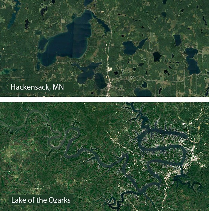
A visual comparison of natural lakes near Hackensack, MN and Lake of the Ozarks, a Missouri reservoir. Natural lakes tend to be rounder than reservoirs.
Reservoirs vs Lakes
Physical Differences
Though they seem similar to one another, reservoirs and lakes are different in a number of ways. One way to differentiate them is by their shape when viewed from above. Reservoirs usually have a dendritic appearance, thin at the upper stretches and thicker toward the dam. This is a result of the water backing up into the feeding streams as the reservoir filled in. Natural lakes, on the other hand, are often much more rounded, due to the processes that form them (glacial, volcanic, tectonic, impact crater).
Reservoirs are deeper at the dam and become shallower at the upper end. The deepest part of a natural lake is generally at the center.
Differences in Water Quality
Reservoirs usually have greater inputs of pollutants than natural lakes. This is primarily due to the greater volume of water flowing into reservoirs than lakes. However, this greater inflow also means that water must be flowing out of the reservoir at a faster rate than in natural lakes. The amount of time a waterbody holds a particular unit of water is called its residence or retention time. Among Missouri reservoirs, retention times vary considerably. For example, Taneycomo water is replaced every 3 days on average, while Stockton Lake water sticks around for 1.2 years. The great Lake Superior, a natural lake, has a retention time of 500 years.
The water quality in natural lakes tends to improve toward the center of the lake. In reservoirs, water quality improves longitudinally, toward the dam. For reservoirs, this is largely due to the deposition of sediments and other materials as the water velocity decreases.
What happens downstream of a dam is another thing to consider. Typically the water coming out of the dam has lower concentrations of nutrients and sediments than the stream . In some cases, though, reservoir managers may choose to pull water through the dam from near the bottom of the lake. This is called selective withdrawal. Deep, hypolimnetic water is colder, has higher concentrations of nutrients and less oxygen than the surface water. Sending this water downstream can have significant effects on the physical, chemical and biological characteristics of the stream.
When several reservoirs occur on the same river, the first reservoir often has higher concentrations of nutrients and suspended sediments. An example of this is the Jackson County lakes, Jacomo, Blue Springs and Prairie Lee. See the figure below.
Hopefully this helps in your understanding of reservoirs. I apologize in advance, but I'm going to continue calling our reservoirs “lakes”. The RMVP just doesn’t have the same ring to it.
Originally published in 2003

A series of Jackson County, Missouri "lakes" (they're actually reservoirs). Water flows from south to north in this system. Google Earth photo.